Geography and Map
Geography of Nattika Grama Panchayat
Nattika Grama Panchayat is one of the important coastal grama panchayats in Thrissur district, Kerala. Since it is located close to the Arabian Sea, fishing and agriculture are important sources of livelihood for the people. The coastal region, paddy fields, coconut plantations, and water bodies are some of the major geographical features of Nattika.
Location
Nattika Grama Panchayat is situated in the western coastal region of Thrissur district. Its proximity to the Arabian Sea influences the geography, lifestyle, and economic activities of the people living in the panchayat.
Boundaries
West – Arabian Sea
East – Nearby rural areas
North – Chavakkad areas
South – Valappad region
Physical Features
As it is a coastal region, sandy areas, small backwaters, coconut plantations, and paddy fields are commonly found here. Since many areas are low-lying, waterlogging may occur during the rainy season. The proximity of the sea also influences the soil and availability of groundwater in the region.
Climate
Nattika generally experiences a tropical climate. The southwest monsoon provides the major share of rainfall. During summer, the temperature and humidity are relatively high.
Water Resources
Wells, ponds, and rainwater are the main sources of water. As Nattika is a coastal area, some parts may experience the influence of saline water in groundwater. Therefore, rainwater harvesting and water conservation are important for the region.
Economic Geography
The geographical features of Nattika are closely connected with the livelihood of its people. The major economic activities include:
Fishing
Agriculture, especially paddy cultivation and coconut farming
Small-scale trade and related occupations
Income from expatriate workers
Transportation
Nattika Grama Panchayat is connected to nearby areas and the Thrissur urban region through its road network. Road transportation plays an important role in local travel and trade.
Map
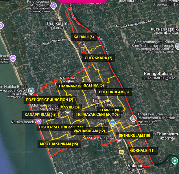
A map of Nattika Grama Panchayat can show its location, boundaries, major roads, residential areas, coastal region, and water bodies. For academic purposes, it is useful to clearly mark the north, south, east, and west directions along with important places on the map.
Summary
Nattika Grama Panchayat is an important coastal region located close to the Arabian Sea. Its major geographical features include the coastline, sandy areas, paddy fields, coconut plantations, and water resources. Economic activities such as fishing and agriculture are closely related to the geography of the region. Due to its coastal nature, some areas may also face environmental issues such as saline-water intrusion and waterlogging.